6 Days Xining to Golmud Tour with Dunhuang
Code: XN04
Tour Type: Private tour, any part of the itinerary can be customized
Guide: Private English-speaking tour guide
Transportation: Private air-conditioned car with experienced driver
Accommodation: Handpicked 4 stars comfort hotels
Meals: 5 western buffet breakfasts
Guide: Private English-speaking tour guide
Transportation: Private air-conditioned car with experienced driver
Accommodation: Handpicked 4 stars comfort hotels
Meals: 5 western buffet breakfasts
From USD1079 per person Free Inquiry
- Itinerary
- Prices
- Reviews
Trip Highlights
- Take in Qinghai Lake’s incomparable beauty by cruise while capturing Chaka Salt Lake’s mirror-like optical illusion reflecting the clear sky.
- Embark on a scenic road trip along Highway 315, comparable to U.S. Route 66, viewing salt lakes, Yardang landforms, and diverse wildlife.
- Marvel at China’s largest salt lake, the jade-like Qarhan Salt Lake, featuring apple green hues.
- Explore the mysterious UNESCO-listed Mogao Caves to enjoy the Chinese Buddhist art along the ancient Silk Road.
- Unveil the Echoing-Sand Mountain and Crescent Lake, the pristine wonderland of once caravans, monks, and envoys.
Expand All
Collapse All
Day 1 Arrival in Xining
Welcome to choose the 6 days Xining to Golmud tour! Upon landing at Xining airport, your private guide and the driver are waiting for you. Then enjoy a door-to-door private car transfer to reach the comfortable hotel we’ve booked for you. The rest of the day is free for your own arrangement.
► Activity Recommendation: (at your own expense)
If time permits, you can explore the city’s vibrant nightlife center, Shuijing Alley Market or Mo’s Food Market, on your own. Both of the two are the lively bustling food streets, offering not only copious amounts of local street food like Qinghai cold noodles, fried bean jelly, sweet handmade yogurt, and deep-fried rice cake with red bean paste or sesame fillings, as well as hand-pulled noodle slices based on mutton soup, and savory lamb kebabs. Join the locals’ queues to gorge on tasty snacks or try some busy stalwart chain restaurants. Also, a rich variety of vegetables and meats, diverse dried fruits and seasonings are available in the markets.
Accommodation: Hampton by Hilton (Xining Jiaboyuan) (4 stars)
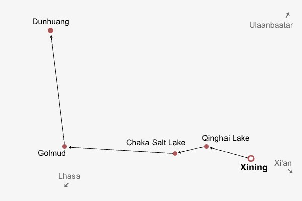
Day 2 Xining - Qinghai Lake - Chaka Salt Lake
Cruise on Qinghai Lake & Visit Erlangjian Peninsula; private transfer to explore Chaka Salt Lake. (B)
This morning, when the city has not yet fully awakened, we’ll depart to explore one of the most beautiful gems in northwestern China, Qinghai Lake. After breakfast, your private guide and the driver will wait for you at the hotel lobby and accompany you on a 2.5-hour scenic drive, during which you may enjoy snow-capped mountains shrouded by dramatic clouds, meadows blooming with rapeseed flowers, and sheep grazing like moving marshmallows, forming impressive film-like scenes. You’ll also view the Sun & Moon Mountain and Daotang River from the car, and listen to their stories involving Princess Wencheng, who once passed through the two places to marry the Tibetan King Songtsen Gampo in 641 AD. 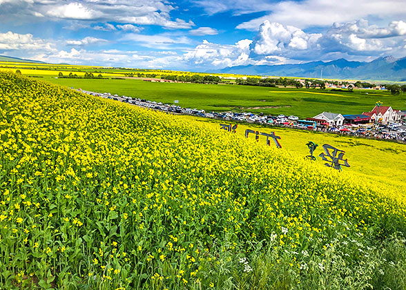
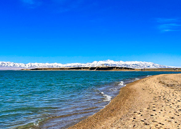 As a vast expanse of deep-blue waters unfurls outside the window, we are approaching Qinghai Lake’s core scenic area, Erlangjian. Upon arrival, you’ll be escorted to the pier and take a 30-minute cruise to the Erlangjian Peninsula, a narrow, sword-like piece stretching into the lake. Legend goes that the God Erlang, one of the most powerful gods in Chinese folklore, once stopped here, pointed his sword at the sky and subdued the lake demons; the sword finally became the white sandy peninsula. Disembark the cruise, and you can stroll along the beach, enjoy the gentle breeze, and feed cute seagulls, with the azure waters and distant snow-capped mountains framed together in breathtaking beauty. However, as the water level of Qinghai Lake rises by 13 centimeters annually, the Erlangjian Peninsula is slowly being submerged by the lake and this dreamy peninsula surrounded by water on three sides may disappear completely within the next few years. Capture the chance to revel in the beauty!
After that, a shuttle bus of the scenic area will send you to the exit. Let’s hit the road for a 2.5-hour drive to Chaka Salk Lake. Please note that we’ll pass by some high-altitude mountain passes of about 3,800 meters (12,470 ft.), and it is suggested that you prepare some oxygen tanks or medicine to help with acclimatization.
► Visit Tips:
1. Wearing red or light-colored clothes can make you stand out against the lake for more beautiful photos.
2. Prepare tons of sunscreen and wear sunglasses, as the longtime reflection of salt and water can cause sunburn and make your eyes dizzy.
3. If interested, you can taste a blue ice cream by yourself (CNY 15), which is said to be made of Chaka Lake’s salt, with a slight salty flavor.
Finishing the visit, the guide and the driver will escort you to the nearby Chaka Town to check into a cozy hotel.
Meals: Breakfast
Accommodation: Chaka Evening Maple Hotel (4 stars)

Rapeseed Flowers near Qinghai Lake

Enjoy Crystal Waters of Qinghai Lake
After that, a shuttle bus of the scenic area will send you to the exit. Let’s hit the road for a 2.5-hour drive to Chaka Salk Lake. Please note that we’ll pass by some high-altitude mountain passes of about 3,800 meters (12,470 ft.), and it is suggested that you prepare some oxygen tanks or medicine to help with acclimatization.
★ Unique Experience: Encounter with China’s Mirror of Sky
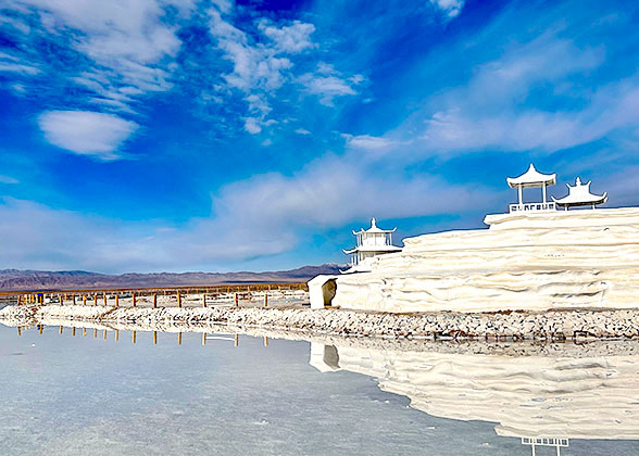
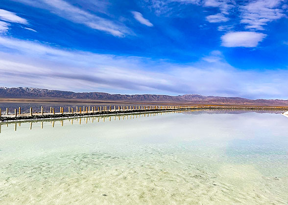
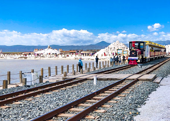
After arrival, your guide will lead you to enter a pure white world. If you choose to walk deep into the shallow lake’s heart, it takes about 40 minutes for a single distance; while most visitors prefer a retro slow train taking about 30 minutes to save energy, and you can pay for it on-site if you like (CNY 50 for a single trip). After reaching the final stop, if you’d like to step into the central lake for a perfect mirror-like reflection, you can rent a pair of shoe protectors at your own expense (CNY 10). However, a sunny day is very crucial for high-quality photographs, and the afternoon sunlight generally offers more chances, especially in places with fewer people and small ripples on the water surface. In addition, you’ll glimpse the world’s largest salt sculpture display outdoors made from thousands of tons of salt, carving the images of Genghis Khan, phoenixes, pavilions, palaces, and Chinese goddesses.► Visit Tips:
1. Wearing red or light-colored clothes can make you stand out against the lake for more beautiful photos.
2. Prepare tons of sunscreen and wear sunglasses, as the longtime reflection of salt and water can cause sunburn and make your eyes dizzy.
3. If interested, you can taste a blue ice cream by yourself (CNY 15), which is said to be made of Chaka Lake’s salt, with a slight salty flavor.
Finishing the visit, the guide and the driver will escort you to the nearby Chaka Town to check into a cozy hotel.
Meals: Breakfast
Accommodation: Chaka Evening Maple Hotel (4 stars)

White Surface of Chaka Salt Lake

Retro Train at Chaka Salt Lake
Day 3 Chaka Salt Lake - Golmud
8.5-hour road trip to Golmud, visiting Little Chaidan Lake, U-shaped Highway, East Taijnar Salt Lake, and Nanbaxian Yardang Landform en route. (B)
This morning, waving goodbye to Chaka Town, your private guide and the driver will accompany you on an 8.5-hour scenic road trip through around 800 km (500 mi), with plenty of wildlife like wild camels, hares, horses, wild sheep, and wild yaks, along with natural wonders including the dramatic Qaidam Basin, salt lakes, and unique yardang landforms. After passing by the small city, Delingha, famous for the Chinese poet Haizi, we’ll arrive at the first highlight, Little Chaidan Lake. We can park the car by the lake; get out of the car and enjoy a short time stroll along the lakeshore, taking in the distant snow mountains looming over the sapphire waters. Then, take a drive meandering through one of China’s most beautiful highways, Highway 315, the counterpart of U.S. Route 66, and pass by the famous U-shaped Highway. Prepare your long-focus camera to capture the amazing optical illusion of a 90-degree steep slope.
Afterward, continue to East Taijnar Salt Lake, which features a high Mg/Li ratio, along with other ions like sodium and potassium, resulting in its Tiffany-blue waters, which can sometimes transfer to apple green colors, as well as white salt flats, and diverse landscapes. Next, we’ll move on to Nanbaxian Yardang Landform, one of the largest Yardang landforms on the planet. On the edge of Lop Nur, the unique landscape has been formed through wind erosion over the course of 75 million years, leaving the elongated, sculpted ridges and various shaped awe-inspiring mounds, resembling towers, fortresses, and crouching giant beasts. The eerie cries of the wind also add an indescribable mystique to this Mars-like land. Finish visiting, and we’ll continue the road trip to Golmud for hotel check-in.
Meals: Breakfast
Accommodation: Lavande Hotel (Golmud Bayilu Underground Commercial Street Kunlun Park) (4 stars)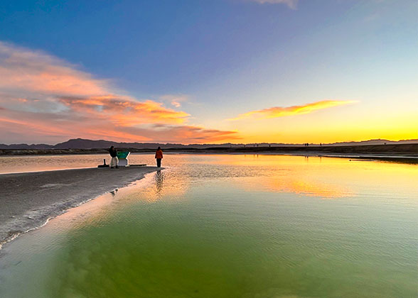
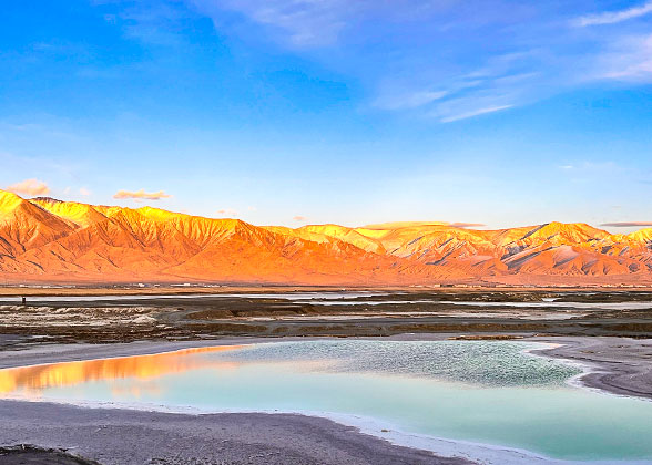

Little Chaidan Lake

A Beautiful Salt Lake en Route
Day 4 Golmud - Dunhuang
Visit Qarhan Salt Lake, Yangguan Pass; private transfer to the hotel in Dunhuang. (B)
When the Mongolians migrated to the Tarim Basin and discovered an oasis, they shouted "Golmud," meaning "many rivers" in Mongolian. Over time, this oasis gradually developed into the now remote desert city, prosperous as the hub of the world’s highest Qinghai-Tibet Railway, and also boasting China’s largest natural salt lake. This morning, the guide and the driver will accompany you to explore the emerald-like Qarhan Salt Lake, which is about 56 times the size of the Chaka Salt Lake. Stretching more than 160 kilometers (99 mi) long from east to west and 20 to 40 kilometers (12-25 mi) wide, it covers an area of 5,800 square kilometers, whose salt layers can be astonishingly thick from 2 to 20 meters (6.5-65 ft.). The salt crystallized on the lake surface like flowers and corals. Walking on the 32-kilometer-long "Salt Bridge" to take in the apple green vibrant hues would be mesmerizing, and any shot you take will be a blockbuster! Please prepare a coat to protect against occasional strong winds and do use high-factor sunscreen. When stepping into the lake, please be aware of the black salt caves hidden in the hard salt flats, in case of falling off the empty bottoms.
After the visit, we’ll hit the road and drive to Dunhuang. Before arriving at the oasis city, we’ll stop by Yangguan Pass, which had been the throat of ancient China's land transportation and a must-pass gateway on the southern route of the Silk Road since the Western Han Dynasty (206 BC-AD 25). The once-famous pass has long collapsed in the Gobi Desert, with only a lonely beacon tower of 4.7 meters high remaining, about 7 meters high before. However, today a lot of antique buildings have been reconstructed, including the fortress, gate, and city walls, which evoke an image of the bustle and vitality that once existed in this border town. At last, capture the stunning sunset over the desolate beacon tower, standing for thousands of years in the vast wild desert. Then, you’ll be escorted by your guide and the driver to check in at the hotel in Dunhuang.
Meals: Breakfast
Accommodation: Dunhuang Hotel (4 stars) - Building No. 8
Day 5 Dunhuang
Explore Mogao Caves, Echoing-Sand Mountain & Crescent Lake. ( (B)
Today, follow your private guide to explore the hidden gems across the desert city, Dunhuang, a testament to millennia of exceptional civilization and faiths, to unveil the layered Buddhism's past in mysterious caves and listen to the sound of camel bells ring in boundless sand dunes. First, pay a visit to the UNESCO-listed Mogao Caves, feeling the cultural and historical soul of Dunhuang, where over two thousand colorful statues and 45,000 square meters of murals are preserved in 735 caves. Two films will first provide you with the historical background and some details of the most gorgeous caves. Accompanied by the guide, you’ll then gawp at eight caves, which rotate to open to the public in an irregular sequence, to take in the art masterpieces from the Northern Wei to the Yuan Dynasties (386-1368 AD). The highlights include the nine-story giant Buddha housed in Cave 96; and Cave 257, which narrates the vivid story of "Nine-Colored Deer Jātaka”, with 8 plots telling of the Buddha in his previous life as a nine-colored deer. He saved a drowning man only to be betrayed, which led to a king’s hunt and eventually awakened the king's conscience.
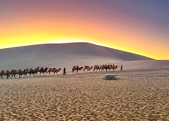
In the afternoon, we’ll depart to witness the true natural wonder, Echoing-Sand Mountain and Crescent Lake, where an oasis with the crescent-like spring has been nestled deep in the vast, desolate desert for thousands of years. It once shielded countless caravans, monks, and envoys along the Silk Road, where they could stop for water supply, rest, and then continued on their long journey. Following the guide, you can climb up the timber towers and pavilions nearby to enjoy the lake closely. As the sun gradually dips below the horizon, the golden light casts red and orange hues over the sand dunes, seeming to turn them on fire. It’s the best time to climb up along the wooden ladder steps to the sand dune top for a panoramic view. If you are with high energy, it is available to try sandboarding, desert off-road motorcycling, and camel riding at your own expense.
After the visit, your guide and the driver will escort you back to the hotel. If you’d like to explore the vibrant, bustling Dunhuang Night Market, they can also drop you there. You can not only taste local snacks like grilled fish, red willow lamb skewers, fluffy stir-fried yogurt, and sweet yet sour apricot juice, but also discover a range of handicrafts and accessories, including replica sculptures of images from the Dunhuang Grottoes and a variety of refrigerator magnets. After the exploration, you can go back to the hotel by taxi on your own.
Meals: Breakfast
Accommodation: Dunhuang Hotel (4 stars) - Building No. 8
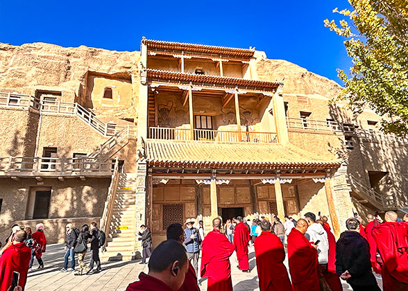

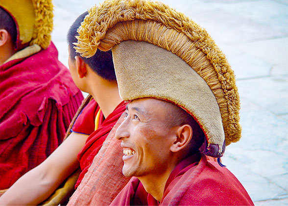
Tibetan Monks Visit Mogao Caves

Echoing-Sand Mountain, Dunhuang
Day 6 Dunhuang Departure
Explore Dunhuang Museum; private transfer to the airport or train station. (B)
After breakfast, your private guide and the driver will wait for you at the hotel lobby, and we’ll then start today’s exploration of the Dunhuang Museum, which narrates the region’s history for thousands of years, mainly focusing on the relics about the Silk Road and Mogao Caves. Apart from enjoying exhibits like stone tomb guardian beasts, stone pagodas, bamboo slips, and ancient bricks with carved portraits, you’ll also be amazed at the replica of Cave 45, characterized by a feast with musical scenes. Additionally, the museum boasts a unique exterior, modeled after the Han-style Great Wall and beacon towers. Entering it is like stepping into a cave complex, with distinctive walls and corridors resembling those of ancient grottoes.
Your Xining to Dunhuang tour will end here, and later, your guide and the driver will escort you to the airport or train station for your onward journey. Wishing you a pleasant trip!
If you want to explore more about the Silk Road in Xinjiang or the Central Asian countries like Kyrgyzstan and Uzbekistan, please contact our travel consultant to tailor your ideal journey!
Meals: Breakfast
Expand All
Collapse All
This trip can be customized to meet your individual needs!
Tour Prices
| 2-3 travelers | 4-5 travelers |
|---|---|
USD1409 | USD1079 |
- Prices are per person on twin sharing.
- If you are a group of 6 people or more, we will offer a more favorable price by your group size.
- Note: Hotel room rates and transfer fee will get increased in summer vacation of Jul and Aug.
Price Includes
- Private English-speaking guide
- Private driver & air-conditioned vehicle
- Hotel accommodation with breakfasts
- Entrance fees to tourist sites
Price Excludes
- International and domestic airfares
- Entry visa fees
- Tips or gratuities for guide and driver
- Personal expenses
Itineraries you may also like:

